ACCESS TO TRANSPORTATION INFRASTRUCTURE
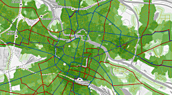
The map presents transportation infrastructure accessibility for a given place. Using shades of green it conveys how well the area is equipped with public transportation and road network. The greener the shade the better accessibility.This tool can be useful to residents, investors and other stakeholders alike. The map allows to compare access to transportation infrastracture between December 2021 and April 2024, viewing changes in any selected location.
Notes
- Accessibility was calculated using infrastructure state as of April 2024. By turning on additional transportation layers you can see what lies ahead in 2026 and assess potential for change.
- Public transportation network data represents its ideal state. Temporary changes in routes due to maintenance are not shown.
- We are commited to updating this map after significant changes in transportation network but no more than annually.
Attribution
This map was envisioned and prepared by Sustainable Transportation Office of City of Wrocław. Web Application was authored by Wrocław Spatial Information System.


